Port Drive Upgrade
QLD / As Built
Port of Brisbane Pty Ltd (PBPL) is responsible, through a Road Franchise Agreement with the Department of Main Roads (TMR), for the maintenance and upgrade of Port Drive at Port Gate...
Read MoreReview all the most progressive assets and projects registered and certified with the ISC for an IS Rating. If your asset or project is not listed below, please speak to your IS Project Manager or contact casemanager@iscouncil.org for more information.
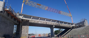
Port of Brisbane Pty Ltd (PBPL) is responsible, through a Road Franchise Agreement with the Department of Main Roads (TMR), for the maintenance and upgrade of Port Drive at Port Gate...
Read More
Description: The project comprises the following key scope items: • Construction of a new four lane bridge over the Cranbourne rail corridor to connect Pound Road West and Remington Drive. • Upgrades to Pound Road West and Remington Drive from one lane to two lanes in both directions to improve through traffic capacity. • Shared walking and cycling
Read More
Description: The Princes Highway East Duplication – Kilmany Section (PHEK) is approximately 5.1km long and extends from east of Maffra-Rosedale Road Nambrok, to Velore Road, Kilmany. Rating Highlights Category Credits Achievements/Risks Materials Mat-1 The Project achieved a verified level of 3 with a score of 8.13. The Project demonstrated a total materials emission reduction of
Read MoreDescription The Project is a program of works that has been initiated by Queensland Department of Transport and Main Roads to modernise and allow the expansion of the South-East Queensland passenger train fleet to support the region’s population and economic growth, while reducing road congestion and associated emissions. Trains will be manufactured and maintained by
Read More
Project Description: Rookwood Weir is a mass concrete structure with fixed crest spillway, stilling basin, left and right abutments, low flow outlet, and dedicated fish and turtle passage solutions. Situated on the Fitzroy River, 66km south-west of Rockhampton, the completed weir will rise 16.2m above the riverbed and have a full supply volume of 74,325
Read More
Description: Rookwood Weir is a $367 million water infrastructure investment to drive new economic and employment opportunities for the agricultural industry and the community of Central Queensland. It is a mass concrete structure with fixed crest spillway, stilling basin, left and right abutments, low flow outlet, and dedicated fish and turtle passage solutions. Situated on
Read More
The project relates to the development of the reclamation area in Rous Head and comprises partitioning into lots, construction of the access roads, and the various services to the boundaries of the...
Read More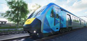
The $1.1 billion Rail Systems Alliance is being delivered by a consortium comprising CPB Contractors, Bombardier Transportation and Metro Trains Melbourne. It has registered for a Design v1.2 IS Rating.
Read More
Description The Tauriko Enabling Works will improve safety at intersections of SH29 with Redwood Lane, Belk Road and Cambridge Road, enable development of up to 2400 homes within Tauriko West, support expansion of Tauriko Business Estate, protect the freight route to the Port, improve journey reliability and access to public transport, walking and cycling. Rating
Read More
The State road network in South Australia is one of the state’s biggest infrastructure assets and covers approximately 25% of the state’s total road network. The network consists of over 13,000km of sealed roads and 10,000km of unsealed roads, tunnels, bridges, traffic signals, signage, verge and drainage. DM Roads are responsible for maintaining Zones 1 (metro) and 3 (North) of the network and deliver a combination of Base Service, Minor Works, Annual Renewal Works and Minor capital works.
Read More
Description The Union & Mont Albert Rd Level Crossing Removal Project is located on the Belgrave / Lilydale rail line, approximately 12 km east of the Melbourne CBD. The project boundary is located within the City of Booroondara and the Whitehorse City Council municipalities in the suburbs of Surrey Hills and Mont Albert. The level
Read More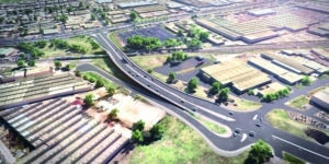
The South Gippsland Highway level crossing impedes the flow of 31,000 cars and trucks each weekday, with boom gates down for a third of the two-hour morning peak. The Victorian Government announced the removal of this crossing in November 2018 as one of 25 additional new crossings to be removed. The final design solution was
Read More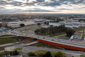
Description The South Gippsland Highway level crossing impedes the flow of 31,000 cars and trucks each weekday, with boom gates down for a third of the two-hour morning peak. The Victorian Government announced the removal of this crossing in November 2018 as one of 25 additional new crossings to be removed. The final design solution
Read More
Description The Stockinbingal to Parkes section of the Inland Rail alignment is an enhancement project modifying specific sites along 170km of existing rail in regional New South Wales. The works planned to be completed as part of this project are: – Increasing vertical clearance under the Wyndham Avenue road bridge in Forbes; and – Building
Read More
Description Sunbury Road provides direct access to the Tullamarine Freeway, connecting road users with high capacity links to Melbourne’s CBD, the wider metropolitan area, as well as regional Victoria and interstate. It is also the primary route for trips from within the corridor to key employment hubs in Melbourne’s north including Epping, Somerton and Broadmeadows.
Read More
Description: The Sydney Metro City & Southwest (SMCSW) project will extend Sydney Metro Northwest to the CBD through Chatswood and beyond to Bankstown. The project is being delivered through a suite of contracts for the tunnels, stations, line-wide infrastructure and systems. The Line-wide Works (LW Works) package is a key component of SMCSW with works
Read More
Description Sydney Metro is Australia’s largest public transport project, transforming Sydney with more trains and faster services. At Central Station, construction includes: Two new underground concourses North-South Concourse above the new Metro station Central Walk for better connectivity to trains, light rail, and new Metro platforms Demolition and reconstruction of suburban rail platforms 12, 13,
Read More
The $8.3 billion Sydney Metro Northwest is Australia’s biggest public transport project and a priority infrastructure investment for the NSW Government. It is the first stage of Sydney Rapid...
Read More
Description The Sydney Metro West – Central Tunnelling Package contract includes the delivery of twin 11 kilometre tunnels and excavation of five station boxes at Sydney Olympic Park, North Strathfield, Burwood North, Five Dock and The Bays. A crossover cavern at Burwood North and one of the two precast facilities at Eastern Creek where more
Read MoreThe Sydney Metro West, Eastern Tunnelling Package (ETP) involves the delivery of: Enabling works such as demolition, utility supply to construction sites, utility adjustments and modifications to the existing transport network Mined crossover cavern construction east of The Bays Station 4.2km of TBM Tunnel excavation, 650m of mined tunnels and 7 cross
Read MoreDescription The Transport Access Program (TAP) aims to enhance the experience of public transport customers by providing accessible, modern, secure, and integrated transport infrastructure. Upgrades to two existing train stations will include the following: Construction of new lifts for access to station platforms and existing footbridges, complete with lift landings, canopies, throw screens, and support
Read More
Description The Transport for New South Wales (TfNSW) Transport Access Program (TAP) is an initiative to provide a better experience for public transport customers by delivering accessible, modern, secure and integrated transport infrastructure. This project consists of six station upgrades which are delivered under Laing O’Rourke’s Managing Contractor Contract. The six stations are referred to
Read More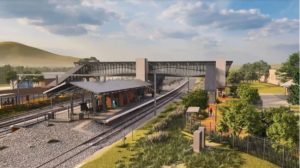
Description The Unanderra Station Upgrade Project (the Project) is part of the third tranche of Transport for NSW’s Transport Access Program, known as TAP 3 and seeks to improve access to public transport for people with disability or limited mobility, parents and careers with prams, and customers with luggage. Providing accessible transport services for everyone
Read More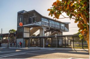
Project Description The project is part of the NSW Government’s the Transport Access Program, which aims to provide a better experience for public transport customers by delivering accessible, modern, secure and integrated transport infrastructure. Under the TAP program, five train stations were upgraded to provide accessible access to people with a disability, limited mobility, parents/carers
Read More
Description: The upgrade works (the Project) were completed for Waitara Station as part of the Transport Access Program, an NSW Government initiative delivering safe, modern and accessible public transport infrastructure across the state. Providing accessible transport services for everyone in the community is one of the six priorities for Transport for NSW’s Future Transport Strategy.
Read More
Description Te Ahu a Turanga – Manawatū Gorge Highway is an 11.5km new highway between Woodville & Ashhurst, with two lanes each way. A major slip in April 2017 left SH3 through the Manawatū Gorge impassable. This new road is being built over the Ruahine Range, to provide a safe, resilient, and efficient route. The
Read More
Te Kori Scott Point is a 16.4ha area of land in the northwest of Auckland that is about to be transformed from a rural landscape to a public park to meet the needs of a new community.
Read More